2019 Edition
CIA World Factbook 2019 Archive (Wayback Machine)
Introduction
Background
Discovered and claimed for Spain in 1499, Aruba was acquired by the Dutch in 1636. The island's economy has been dominated by three main industries. A 19th century gold rush was followed by prosperity brought on by the opening in 1924 of an oil refinery. The last decades of the 20th century saw a boom in the tourism industry. Aruba seceded from the Netherlands Antilles in 1986 and became a separate, semi-autonomous member of the Kingdom of the Netherlands. Movement toward full independence was halted at Aruba's request in 1990.
Geography
Area
- Land
- 180 sq km
- Total
- 180 sq km
- Water
- 0 sq km
Area Comparative
slightly larger than Washington, DC
Climate
tropical marine; little seasonal temperature variation
Coastline
68.5 km
Elevation
- Highest Point
- Ceru Jamanota 188 m
- Lowest Point
- Caribbean Sea 0 m
Environment Current Issues
difficulty in properly disposing of waste produced by large numbers of tourists; waste burning that occurs in the landfill causes air pollution and poses an environmental and health risk; ocean environmental damage due to plastic pollution
Geographic Coordinates
12 30 N, 69 58 W
Geography Note
a flat, riverless island renowned for its white sand beaches; its tropical climate is moderated by constant trade winds from the Atlantic Ocean; the temperature is almost constant at about 27 degrees Celsius (81 degrees Fahrenheit)
Land Boundaries
0 km
Land Use
- Agricultural Land
- 11.1% (2016 est.)
- Agricultural Land Arable Land
- 11.1% (2016 est.)
- Agricultural Land Permanent Crops
- 0% (2016 est.)
- Agricultural Land Permanent Pasture
- 0% (2016 est.)
- Forest
- 2.3% (2016 est.)
- Other
- 86.6% (2016 est.)
Location
Caribbean, island in the Caribbean Sea, north of Venezuela
Map References
Central America and the Caribbean
Maritime Claims
- Exclusive Economic Zone
- 200 nm
- Territorial Sea
- 12 nm
Natural Hazards
hurricanes; lies outside the Caribbean hurricane belt and is rarely threatened
Natural Resources
NEGL; white sandy beaches foster tourism
Population Distribution
most residents live in or around Oranjestad and San Nicolaas; most settlments tend to be located on the less mountainous western side of the island
Terrain
flat with a few hills; scant vegetation
People and Society
Age Structure
- 0 14 Years
- 17.61% (male 10,304 /female 10,227)
- 15 24 Years
- 12.53% (male 7,355 /female 7,253)
- 25 54 Years
- 41.29% (male 23,187 /female 24,946)
- 55 64 Years
- 14.51% (male 7,910 /female 9,005)
- 65 Years And Over
- 14.06% (male 6,422 /female 9,967) (2018 est.)
Birth Rate
12.3 births/1,000 population (2018 est.)
Death Rate
8.5 deaths/1,000 population (2018 est.)
Dependency Ratios
- Elderly Dependency Ratio
- 17.5 (2015 est.)
- Potential Support Ratio
- 5.7 (2015 est.)
- Total Dependency Ratio
- 44.6 (2015 est.)
- Youth Dependency Ratio
- 27 (2015 est.)
Drinking Water Source
- Improved Rural
- 98.1% of population
- Improved Total
- 98.1% of population
- Improved Urban
- 98.1% of population
- Unimproved Rural
- 1.9% of population
- Unimproved Total
- 1.9% of population (2015 est.)
- Unimproved Urban
- 1.9% of population
Education Expenditures
6.2% of GDP (2016)
Ethnic Groups
Aruban 66%, Colombian 9.1%, Dutch 4.3%, Dominican 4.1%, Venezuelan 3.2%, Curacaoan 2.2%, Haitian 1.5%, Surinamese 1.2%, Peruvian 1.1%, Chinese 1.1%, other 6.2% (2010 est.)
Infant Mortality Rate
- Female
- 7.2 deaths/1,000 live births
- Male
- 13.6 deaths/1,000 live births
- Total
- 10.4 deaths/1,000 live births (2018 est.)
Languages
Papiamento (official) (a creole language that is a mixture of Portuguese, Spanish, Dutch, English, and, to a lesser extent, French, as well as elements of African languages and the language of the Arawak) 69.4%, Spanish 13.7%, English (widely spoken) 7.1%, Dutch (official) 6.1%, Chinese 1.5%, other 1.7%, unspecified 0.4% (2010 est.)
Life Expectancy at Birth
- Female
- 80.3 years
- Male
- 74.1 years
- Total Population
- 77.1 years (2018 est.)
Literacy
- Definition
- age 15 and over can read and write
- Female
- 97.5% (2015)
- Male
- 97.5%
- Total Population
- 97.5%
Major Infectious Diseases
note: active local transmission of Zika virus by Aedes species mosquitoes has been identified in this country (as of August 2016); it poses an important risk (a large number of cases possible) among US citizens if bitten by an infective mosquito; other less common ways to get Zika are through sex, via blood transfusion, or during pregnancy, in which the pregnant woman passes Zika virus to her fetus
Major Urban Areas Population
30,000 ORANJESTAD (capital) (2018)
Median Age
- Female
- 41.2 years
- Male
- 37.8 years
- Total
- 39.5 years (2018 est.)
Nationality
- Adjective
- Aruban; Dutch
- Noun
- Aruban(s)
Net Migration Rate
8.6 migrant(s)/1,000 population (2018 est.)
Population
116,576 (July 2018 est.)
Population Growth Rate
1.24% (2018 est.)
Religions
Roman Catholic 75.3%, Protestant 4.9% (includes Methodist 0.9%, Adventist 0.9%, Anglican 0.4%, other Protestant 2.7%), Jehovah's Witness 1.7%, other 12%, none 5.5%, unspecified 0.5% (2010 est.)
Sanitation Facility Access
- Improved Rural
- 97.7% of population (2015 est.)
- Improved Total
- 97.7% of population (2015 est.)
- Improved Urban
- 97.7% of population (2015 est.)
- Unimproved Rural
- 2.3% of population (2015 est.)
- Unimproved Total
- 2.3% of population (2015 est.)
- Unimproved Urban
- 2.3% of population (2015 est.)
School Life Expectancy Primary To Tertiary Education
- Female
- 14 years (2012)
- Male
- 13 years
- Total
- 14 years
Sex Ratio
- 0 14 Years
- 1.01 male(s)/female
- 15 24 Years
- 1.01 male(s)/female
- 25 54 Years
- 0.93 male(s)/female
- 55 64 Years
- 0.88 male(s)/female
- 65 Years And Over
- 0.64 male(s)/female
- At Birth
- 1.02 male(s)/female
- Total Population
- 0.9 male(s)/female (2018 est.)
Total Fertility Rate
1.83 children born/woman (2018 est.)
Unemployment Youth Ages 15 24
- Female
- 27.5% (2010 est.)
- Male
- 29.9%
- Total
- 28.9%
Urbanization
- Rate Of Urbanization
- 0.67% annual rate of change (2015-20 est.)
- Urban Population
- 43.5% of total population (2019)
Government
Administrative Divisions
none (part of the Kingdom of the Netherlands)
Capital
- Geographic Coordinates
- 12 31 N, 70 02 W
- Name
- Oranjestad
- Time Difference
- UTC-4 (1 hour ahead of Washington, DC, during Standard Time)
Citizenship
see the Netherlands
Constitution
previous 1947, 1955; latest drafted and approved August 1985, enacted 1 January 1986 (regulates governance of Aruba but is subordinate to the Charter for the Kingdom of the Netherlands); in 1986, Aruba became a semi-autonomous entity within the Kingdom of the Netherlands
Country Name
- Conventional Long Form
- none
- Conventional Short Form
- Aruba
- Etymology
- the origin of the island's name is unclear; according to tradition, the name comes from the Spanish phrase "oro huba" (there was gold), but in fact no gold was ever found on the island; another possibility is the native word "oruba," which means "well-situated"
Dependency Status
constituent country of the Kingdom of the Netherlands; full autonomy in internal affairs obtained in 1986 upon separation from the Netherlands Antilles; Dutch Government responsible for defense and foreign affairs
Diplomatic Representation From The Us
the US does not have an embassy in Aruba; the Consul General to Curacao is accredited to Aruba
Diplomatic Representation In The Us
none (represented by the Kingdom of the Netherlands); note - Guillfred BESARIL (since 20 November 2017) is Minister Plenipotentiary of Aruba, seated with his cabinet in the Aruba House (Arubahuis) in The Hague
Executive Branch
- Cabinet
- Council of Ministers elected by the Legislature (Staten)
- Chief Of State
- King WILLEM-ALEXANDER of the Netherlands (since 30 April 2013); represented by Governor General Alfonso BOEKHOUDT (since 1 January 2017)
- Election Results
- Evelyn WEVER-CROES (MEP) elected prime minister; percent of legislative vote - NA
- Elections Appointments
- the monarchy is hereditary; governor general appointed by the monarch for a 6-year term; prime minister and deputy prime minister indirectly elected by the Staten for 4-year term; election last held on 27 September 2013 (next to be held by September 2017)
- Head Of Government
- Prime Minister Evelyn WEVER-CROES (since 17 November 2017)
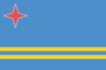
Flag Description
blue, with two narrow, horizontal, yellow stripes across the lower portion and a red, four-pointed star outlined in white in the upper hoist-side corner; the star represents Aruba and its red soil and white beaches, its four points the four major languages (Papiamento, Dutch, Spanish, English) as well as the four points of a compass, to indicate that its inhabitants come from all over the world; the blue symbolizes Caribbean waters and skies; the stripes represent the island's two main "industries": the flow of tourists to the sun-drenched beaches and the flow of minerals from the earth
Government Type
parliamentary democracy; part of the Kingdom of the Netherlands
Independence
none (part of the Kingdom of the Netherlands)
International Organization Participation
Caricom (observer), FATF, ILO, IMF, Interpol, IOC, ITUC (NGOs), UNESCO (associate), UNWTO (associate), UPU
Judicial Branch
- Highest Courts
- Joint Court of Justice of Aruba, Curacao, Sint Maarten, and of Bonaire, Sint Eustatius and Saba or "Joint Court of Justice" (sits as a 3-judge panel); final appeals heard by the Supreme Court in The Hague, Netherlands
- Judge Selection And Term Of Office
- Joint Court judges appointed for life by the monarch
- Subordinate Courts
- Court in First Instance
Legal System
civil law system based on the Dutch civil code
Legislative Branch
- Description
- unicameral Legislature or Staten (21 seats; members directly elected in a single nationwide constituency by proportional representation vote; members serve 4-year terms)
- Election Results
- percent of vote by party AVP 39.8%, MEP 37.6%, POR 9.4%, RED 7.1%, other 6.1%; seats by party - AVP 9, MEP 9, POR 2, RED 1; composition as of October 2018 - men 14, women 7, percent of women 33.3%
- Elections
- last held on 22 September 2017 (next to be held in September 2021)
National Anthem
- Lyrics Music
- Juan Chabaya 'Padu' LAMPE/Rufo Inocencio WEVER
- Name
- "Aruba Deshi Tera" (Aruba Precious Country)
National Holiday
National Anthem and Flag Day, 18 March (1976)
National Symbol S
Hooiberg (Haystack) Hill; national colors: blue, yellow, red, white
Political Parties And Leaders
Aruban People's Party or AVP [Michiel "Mike" EMAN] Democratic Electoral Network or RED [L.R. CROES] People's Electoral Movement Party or MEP [Evelyn WEVER-CROES] Pueblo Orguyoso y Respeta or POR [O.E. ODUBER] Real Democracy or PDR [Andin BIKKER]
Suffrage
18 years of age; universal
Economy
Agriculture Products
aloes; livestock; fish
Budget
- Expenditures
- 755.5 million (2017 est.)
- Revenues
- 681.6 million (2017 est.)
Budget Surplus Or Deficit
-2.7% (of GDP) (2017 est.)
Central Bank Discount Rate
- 31 December 2009
- 3%
- 31 December 2010
- 1%
Commercial Bank Prime Lending Rate
- 31 December 2016
- 7.83%
- 31 December 2017
- 7%
Current Account Balance
- 2016
- $133 million
- 2017
- $22 million
Debt External
- 31 December 2013
- $666.4 million
- 31 December 2014
- $693.2 million
Economy Overview
Tourism, petroleum bunkering, hospitality, and financial and business services are the mainstays of the small open Aruban economy.Tourism accounts for a majority of economic activity; as of 2017, over 2 million tourists visited Aruba annually, with the large majority (80-85%) of those from the US. The rapid growth of the tourism sector has resulted in a substantial expansion of other activities. Construction continues to boom, especially in the hospitality sector.Aruba is heavily dependent on imports and is making efforts to expand exports to improve its trade balance. Almost all consumer and capital goods are imported, with the US, the Netherlands, and Panama being the major suppliers.In 2016, Citgo Petroleum Corporation, an indirect wholly owned subsidiary of Petroleos de Venezuela SA, and the Government of Aruba signed an agreement to restart Valero Energy Corp.'s former 235,000-b/d refinery. Tourism and related industries have continued to grow, and the Aruban Government is working to attract more diverse industries. Aruba's banking sector continues to be a strong sector; unemployment has significantly decreased.
Exchange Rates
- 2013
- 1.79
- 2014
- 1.79
- 2015
- 1.79
- 2016
- 1.79
- 2017
- 1.79
- Currency
- Aruban guilders/florins per US dollar -
Exports
- 2016
- $283.1 million
- 2017
- $137.1 million
Exports Commodities
live animals and animal products, art and collectibles, machinery and electrical equipment, transport equipment
Exports Partners
US 20.2%, Colombia 17.6%, Venezuela 13%, Netherlands 9.1%, Thailand 8.4%, Panama 4.8% (2017)
Fiscal Year
calendar year
GDP Composition By End Use
- Exports Of Goods And Services
- 70.5% (2015 est.)
- Government Consumption
- 25.3% (2015 est.)
- Household Consumption
- 60.3% (2014 est.)
- Imports Of Goods And Services
- -76.6% (2015 est.)
- Investment In Fixed Capital
- 22.3% (2014 est.)
- Investment In Inventories
- 0% (2015 est.)
GDP Composition By Sector Of Origin
- Agriculture
- 0.4% (2002 est.)
- Industry
- 33.3% (2002 est.)
- Services
- 66.3% (2002 est.)
GDP Official Exchange Rate
$2.7 billion (2009 est.) (2017 est.)
GDP Per Capita Ppp
- 2015
- $37,700
- 2016
- $37,300
- 2017
- $37,500
GDP Purchasing Power Parity
- 2015
- $4.112 billion
- 2016
- $4.107 billion
- 2017
- $4.158 billion
GDP Real Growth Rate
- 2015
- -0.4%
- 2016
- -0.1%
- 2017
- 1.2%
Gross National Saving
- 2015
- 15.5% of GDP
- 2016
- 17.2% of GDP
- 2017
- 17% of GDP
Imports
- 2016
- $1.142 billion
- 2017
- $1.122 billion
Imports Commodities
machinery and electrical equipment, refined oil for bunkering and reexport, chemicals; foodstuffs
Imports Partners
US 53.7%, Netherlands 13.1% (2017)
Industries
tourism, petroleum transshipment facilities, banking
Inflation Rate Consumer Prices
- 2016
- -0.9%
- 2017
- -0.5%
Labor Force
51,610 (2007 est.)
Public Debt
- 2016
- 84.7% of GDP
- 2017
- 86% of GDP
Reserves Of Foreign Exchange And Gold
- 31 December 2015
- $828 million
- 31 December 2017
- $921.8 million
Stock Of Broad Money
- 31 December 2016
- $1.257 billion
- 31 December 2017
- $0
Stock Of Domestic Credit
- 31 December 2016
- $1.848 billion
- 31 December 2017
- $1.848 billion
Stock Of Narrow Money
- 31 December 2016
- $1.257 billion
- 31 December 2017
- $0
Taxes And Other Revenues
25.2% (of GDP) (2017 est.)
Unemployment Rate
- 2016
- 7.7%
Energy
Carbon Dioxide Emissions From Consumption Of Energy
1.266 million Mt (2017 est.)
Crude Oil Exports
0 bbl/day (2015 est.)
Crude Oil Imports
0 bbl/day (2015 est.)
Crude Oil Production
0 bbl/day (2018 est.)
Crude Oil Proved Reserves
0 bbl (1 January 2018 est.)
Electricity Access
- Electrification Rural Areas
- 92.5% (2016)
- Electrification Total Population
- 95.6% (2016)
- Electrification Urban Areas
- 100% (2016)
- Population Without Electricity
- 11,364 (2012)
Electricity Consumption
873.3 million kWh (2016 est.)
Electricity Exports
0 kWh (2016 est.)
Electricity From Fossil Fuels
87% of total installed capacity (2016 est.)
Electricity From Hydroelectric Plants
0% of total installed capacity (2017 est.)
Electricity From Nuclear Fuels
0% of total installed capacity (2017 est.)
Electricity From Other Renewable Sources
13% of total installed capacity (2017 est.)
Electricity Imports
0 kWh (2016 est.)
Electricity Installed Generating Capacity
296,000 kW (2016 est.)
Electricity Production
939 million kWh (2016 est.)
Natural Gas Consumption
1 cu m (2017 est.)
Natural Gas Exports
1 cu m (2017 est.)
Natural Gas Imports
1 cu m (2017 est.)
Natural Gas Production
1 cu m (2017 est.)
Natural Gas Proved Reserves
0 cu m (1 January 2014 est.)
Refined Petroleum Products Consumption
8,000 bbl/day (2016 est.)
Refined Petroleum Products Exports
0 bbl/day (2015 est.)
Refined Petroleum Products Imports
7,891 bbl/day (2015 est.)
Refined Petroleum Products Production
0 bbl/day (2015 est.)
Communications
Broadcast Media
2 commercial TV stations; cable TV subscription service provides access to foreign channels; about 19 commercial radio stations broadcast (2017)
Internet Country Code
.aw
Internet Users
- Percent Of Population
- 93.5% (July 2016 est.)
- Total
- 106,309
Telephone System
- Domestic
- ongoing changes in regulations and competition improving teledensity; 31 per 100 fixed-line, 126 per 100 mobile-cellular (2018)
- General Assessment
- modern fully automatic telecommunications system; increased competition through privatization has increased mobile-cellular teledensity; three mobile-cellular service providers are now licensed; MNO (mobile network operator) launched island-wide LTE services; MNP (mobile number portability) introduced (2018)
- International
- country code - 297; landing points for the PAN-AM, PCCS, Deep Blue Cable, and Alonso de Ojeda submarine telecommunications cable system that extends from Trinidad and Tobago, Florida, Puerto Ricco, Jamaica, Guyana, Sint Eustatius & Saba, Suriname, Dominican Republic, BVI, USVI, Haiti, Cayman Islands, the Netherlands Antilles, through Aruba to Panama, Venezuela, Colombia, Ecuador, Peru and Chile; extensive interisland microwave radio relay links (2019)
Telephones Fixed Lines
- Subscriptions Per 100 Inhabitants
- 31 (July 2016 est.)
- Total Subscriptions
- 35,000
Telephones Mobile Cellular
- Subscriptions Per 100 Inhabitants
- 126 (July 2016 est.)
- Total Subscriptions
- 141,000
Transportation
Airports
1 (2013)
Airports With Paved Runways
- 2 438 To 3 047 M
- 1
- Total
- 1 (2019)
Civil Aircraft Registration Country Code Prefix
P4 (2016)
National Air Transport System
- Annual Freight Traffic On Registered Air Carriers
- 0 mt-km (2015)
- Annual Passenger Traffic On Registered Air Carriers
- 2,120,578 (2015)
- Inventory Of Registered Aircraft Operated By Air Carriers
- 19 (2015)
- Number Of Registered Air Carriers
- 3 (2015)
Ports And Terminals
- Cruise Port S
- Oranjestad
- Major Seaport S
- Barcadera, Oranjestad
- Oil Terminal S
- Sint Nicolaas
Roadways
1,000 km (2010)
Military and Security
Military And Security Forces
no regular military forces (2011)
Military Note
defense is the responsibility of the Netherlands; the Aruba security services focus on organized crime and terrorism
Transnational Issues
Disputes International
none
Illicit Drugs
transit point for US- and Europe-bound narcotics with some accompanying money-laundering activity; relatively high percentage of population consumes cocaine