1989 Edition
CIA World Factbook 1989 (Internet Archive)
Geography
Climate
- tropical marine; little seasonal temperature variation
- mostly temperate; arid in southeast; subantarctic in southwest
Coastline
- 1 53 km
- 45,389 km f'limate: persistent cold and relatively narrow annual temperature ranges; winters characterized by continuous darkness, cold and stable weather conditions, and clear skies; summers characterized by continuous daylight, damp and foggy weather, and weak cyclones with rain or snow
- 4,989 km
Comparative area
- slightly less than 2.5 times the size of Washington, DC
- slightly more than 1 .5 times the size of the US; smallest of the world's four oceans (after Pacific Ocean, Atlantic Ocean, and Indian Ocean)
- slightly more than four times the size of Texas
Contiguous zone
24 nm
Continental shelf
200 meters or to depth of exploitation
Disputes
short section of the boundary with Uruguay is in dispute; short section of the boundary with Chile is indefinite; claims British-administered Falkland Islands (Islas Malvinas); claims British-administered South Georgia and the South Sandwich Islands; territorial claim in Antarctica
Environment
- subject to hurricanes and tropical storms (July to October); insufficient freshwater resources; deeply indented coastline provides many natural harbors
- endangered marine species include walruses and whales; ice islands occasionally break away from northern Ellesmere Island; icebergs calved from Arctic Ocean (continued) Argentina western Greenland and extreme northeastern Canada; maximum snow cover in March or April about 20 to 50 centimeters over the frozen ocean and lasts about 10 months; permafrost in islands; virtually icelocked from October to June; fragile ecosystem slow to change and slow to recover from disruptions or damage
- Tucuman and Mendoza areas in Andes subject to earthquakes; pamperos are violent windstorms that can strike Pampas and northeast; irrigated soil degradation; desertification; air and water pollution in Buenos Aires
Extended economic zone
200 nm
Land boundaries
- none
- 9,665 km total; Bolivia 832 km, Brazil 1,224 km, Chile 5,150 km, Paraguay 1,880 km, Uruguay 579 km
Land use
- 18% arable land; 0% permanent crops; 7% meadows and pastures; 16% forest and woodland; 59% other
- 9% arable land; 4% permanent crops; 52% meadows and pastures; 22% forest and woodland; 1 3% other; includes 1% irrigated
Natural resources
- negligible; pleasant climate fosters tourism
- sand and gravel aggregates, placer deposits, polymetallic nodules, oil and gas fields, fish, marine mammals (seals, whales)
- fertile plains of the pampas, lead, zinc, tin, copper, iron ore, manganese, crude oil, uranium
Note
- 420 km east-southeast of Puerto Rico
- major chokepoint is the southern Chukchi Sea (northern access to the Pacific Ocean via the Bering Strait); ships subject to superstructure icing from October to May; strategic location between North America and the USSR; shortest marine link between the extremes of eastern and western USSR; floating research stations operated by the US and USSR
- second-largest country in South America (after Brazil); strategic location relative to sea lanes between South Atlantic and South Pacific Oceans (Strait of Magellan, Beagle Channel, Drake Passage)
Terrain
- mostly low-lying limestone and coral islands with some higher volcanic areas
- central surface covered by a perennial drifting polar icepack which averages about 3 meters in thickness, although pressure ridges may be three times that size; clockwise drift pattern in the Beaufort Gyral Stream, but nearly straight line movement from the New Siberian Islands (USSR) to Denmark Strait (between Greenland and Iceland); the ice pack is surrounded by open seas during the summer, but more than doubles in size during the winter and extends to the encircling land masses; the ocean floor is about 50% continental shelf (highest percentage of any ocean) with the remainder a central basin interrupted by three submarine ridges (Alpha Cordillera, Nansen Cordillera, and Lomonsov Ridge); maximum depth is 4,665 meters in the Fram Basin
- rich plains of the Pampas in northern half, flat to rolling plateau of Patagonia in south, rugged Andes along western border
Territorial sea
- 1 2 nm
- 200 nm (overflight and navigation permitted beyond 1 2 nm)
Total area
- 440 km2; land area: 440 km2; includes Redonda
- 14,056,000 km2; includes Baffin Bay, Barents Sea, Beaufort Sea, Chukchi Sea, East Siberian Sea, Greenland Sea, Hudson Bay, Hudson Strait, Kara Sea, Laptev Sea, and other tributary water bodies
- 2,766,890 km2; land area: 2,736,690 km2
People and Society
Birth rate
- 18 births/ 1,000 population (1990)
- 20 births/ 1 ,000 population (1990)
Death rate
- 6 deaths/ 1 ,000 population (1990)
- 9 deaths/ 1,000 population (1990)
Ethnic divisions
- almost entirely of black African origin; some of British, Portuguese, Lebanese, and Syrian origin
- 85% white, 15% mestizo, Indian, or other nonwhite groups
Infant mortality rate
- 23 deaths/ 1 ,000 live births (1990)
- 32 deaths/ 1,000 live births (1990)
Labor force
- 30,000; 82% commerce and services, 1 1% agriculture, 7% industry (1983)
- 10,900,000; 1 2% agriculture, 31% industry, 57% services (1985 est.) Organized labor 3,000,000; 28% of labor force
Language
- English (official), local dialects
- Spanish (official), English, Italian, German, French
Life expectancy at birth
- 70 years male, 74 years female (1990)
- 67 years male, 74 years female (1990)
Literacy
- 90% (est.)
- 94%
Nationality
- noun — Antiguan(s); adjective— Antiguan
- noun — Argentines); adjective— Argentine
Net migration rate
- — 10 migrants/ 1 ,000 population (1990)
- NEGL migrants/ 1,000 population (1990)
Organized labor
Antigua and Barbuda Public Service Association (ABPSA), membership 500; Antigua Trades and Labor Union (ATLU), 10,000 members; Antigua Workers Union (AWU), 10,000 members (1986 est.)
Population
- 63,726 (July 1990), growth rate 0.3% (1990)
- 32,290,966 (July 1990), growth rate 1.2% (1990)
Religion
- Anglican (predominant), other Protestant sects, some Roman Catholic
- 90% nominally Roman Catholic (less than 20% practicing), 2% Protestant, 2% Jewish, 6% other
Total fertility rate
- 1 .7 children born/ woman (1990)
- 2.8 children born/ woman (1990)
Government
Administrative divisions
- 6 parishes and 2 dependencies*; Barbuda*, Redonda*, Saint George, Saint John, Saint Mary, Saint Paul, Saint Peter, Saint Philip
- 22 provinces (provincias, singular — provincial, 1 national territory* (territorio nacional), and 1 district** (distrito); Buenos Aires, Catamarca, Chaco, Chubut, Cordoba, Corrientes, Distrito Federal**, Entre Rios, Formosa, Jujuy, La Pampa, La Rioja, Mendoza, Misiones, Neuquen, Rio Negro, Salta, San Juan, San Luis, Santa Cruz, Santa Fe, Santiago del Estero, Tierra del Fuego and Antartida e Islas del Atlantico Sur*, Tucuman
Capital
- Saint John's
- Buenos Aires (tentative plans to move to Viedma by 1990 indefinitely postponed)
Communists
- negligible
- some 70,000 members in various party organizations, including a small nucleus of activists
Constitution
- 1 November 1981
- 1 May 1853
Diplomatic representation
- Ambassador Edmund Hawkins LAKE; Chancery at Suite 2H, 3400 International Drive NW, Washington DC 20008; telephone (202) 362-5211 or 5166, 5122, 5225; there is an Antiguan Consulate in Miami; US — the US Ambassador to Barbados is accredited to Antigua and Barbuda, and in his absence, the Embassy is headed by Charge d'Affaires Roger R. GAMBLE; Embassy at Queen Elizabeth Highway, Saint John's (mailing address is FPO Miami 34054); telephone (809) 462-3505 or 3506
- Ambassador Guido Jose Maria DI TELLA; Chancery at 1600 New Hampshire Avenue NW, Washington DC 20009; telephone 202) 939-6400 through 6403; there are Argentine Consulates General in Houston, Miami, New Orleans, New York, San Francisco, and San Juan (Puerto Rico), and Consulates in Baltimore, Chicago, and Los Angeles; US — Ambassador Terence A. TODMAN; Embassy at 4300 Colombia, 1425 Buenos Aires (mailing address is APO Miami 34034); telephone [54] (1) 774-7611 or 8811,9911
Elections
- House of Representatives — last held 9 March 1989 (next to be held 1994); results — percentage of vote by party NA; seats— (17 total) ALP 15, UNDP 1, independent 1
- President — last held 14 May 1989 (next to be held May 1995); results — Carlos Saul Menem was elected; Chamber of Deputies — last held 14 May 1989 (next to be held May 1991); results— JP 47%, UCR 30%, UDC 7%, other 16%; seats— (254 total); JP 122, UCR 93, UDC 11, other 28
Executive branch
- British monarch, governor general, prime minister, deputy prime minister, Cabinet
- president, vice president, Cabinet
Flag
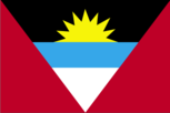
- red with an inverted isosceles triangle based on the top edge of the flag; the triangle contains three horizontal bands of black (top), light blue, and white with a yellow rising sun in the black band
- three equal horizontal bands of light blue (top), white, and light blue; centered in the white band is a radiant yellow sun with a human face known as the Sun of May
Independence
- 1 November 1981 (from UK)
- 9 July 1816 (from Spain)
Judicial branch
- Eastern Caribbean Supreme Court
- Supreme Court (Corte Suprema)
Leaders
- Chief of State— Queen ELIZABETH II (since 6 February 1952), represented by Governor General Sir Wilfred Ebenezer JACOBS (since 1 November 1 98 1 , previously Governor since 1 976); Head of Government — Prime Minister Vere Cornwall BIRD, Sr. (since NA 1976); Deputy Prime Minister Lester BIRD (since N A 1976) Political parties and leaders: Antigua Labor Party (ALP), Vere C. Bird, Sr., Lester Bird; United National Democratic Party (UNDP), Dr. Ivor Heath
- Chief of State and Head of Government— President Carlos Saul MENEM (since 8 July 1989); Vice President Eduardo DUHALDE (since 8 July 1989) Political parties and leaders: Justicialist Party (JP), Antonio Cafiero, Peronist umbrella political organization; Radical Civic Union (UCR), Raul Alfonsin, moderately left of center; Union of the Democratic Center (UCEDE), Alvaro Alsogaray, conservative party; Intransigent Party (PI), Dr. Oscar Alende, leftist party; several provincial parties
Legal system
- based on English common law
- mixture of US and West European legal systems; has not accepted compulsory ICJ jurisdiction
Legislative branch
- bicameral Parliament consists of an upper house or Senate and a lower house or House of Representatives
- bicameral National Congress (Congreso Nacional) consists of an upper chamber or Senate (Senado) and a lower chamber or Chamber of Deputies (Camera de Diputados)
Long-form name
- none
- Argentine Republic
Member of
- ACP, CARICOM, Commonwealth, FAO, G-77, IBRD, ICAO, ILO, IMF, ISO, OAS, UN, UNESCO, WHO, WMO
- CCC, FAO, G-77, GATT, Group of Eight, IADB, IAEA, IBRD, ICAC, ICAO, IDA, IDB— Inter-American Development Bank, IFAD, IFC, IHO, ILO, IMF, IMO, INTELSAT, INTERPOL, IOOC, ISO, ITU, IWC— International Whaling Commission, IWC — International Wheat Council, LAIA, NAM, OAS, PAHO, SELA, UN, UNESCO, UPU, WFTU, WHO, WMO, WTO, WSG
National holiday
- Independence Day, 1 November (1981)
- National Day, 25 May (1810)
Other political or pressure groups
- Antigua Caribbean Liberation Movement (ACLM), a small leftist nationalist group Arctic Ocean led by Leonard (Tim) Hector; Antigua Trades and Labor Union (ATLU), headed by Noel Thomas
- Peronist-dominated labor movement, General Confederation of Labor (Peronistleaning umbrella labor organization), Argentine Industrial Union (manufacturers' association), Argentine Rural Society (large landowners' association), business organizations, students, the Roman Catholic Church, the Armed Forces
Suffrage
- universal at age 18
- universal at age 18
Type
- parliamentary democracy
- republic
Economy
Agriculture
- accounts for 4% of GDP; expanding output of cotton, fruits, vegetables, and livestock sector; other crops — bananas, coconuts, cucumbers, mangoes; not self-sufficient in food
- accounts for 15% of GNP (including fishing); produces abundant food for both domestic consumption and exports; among world's top five exporters of grain and beef; principal crops — wheat, corn, sorghum, soybeans, sugar beets; 1987 fish catch estimated at 500,000 tons
Aid
- Western (non-US) countries, ODA and OOF bilateral commitments (197087), $40 million
- US commitments, including Ex-Im (FY70-88), $1.0 billion; Western (non-US) countries, ODA and OOF bilateral commitments (1970-87), $3.6 billion; Communist countries (1970-88), $718 million
Budget
- revenues $77 million; expenditures $81 million, including capital expenditures of $13 million (1988 est.)
- revenues $11.5 billion; expenditures $13.0 billion, including capital expenditures of $0.93 billion (1988)
Currency
- East Caribbean dollar (plural — dollars); 1 EC dollar (EC$) = 100 cents
- austral (plural — australes); 1 austral (A) = 100 centavos
Electricity
- 49,000 kW capacity; 90 million kWh produced, 1,410 kWh per capita (1989)
- 16,449,000 kW capacity; 46,590 million kWh produced, 1,460 kWh per capita (1989)
Exchange rates
- East Caribbean dollars (ECS) per US$1— 2.70 (fixed rate since 1976)
- australes (A) per US$1 — 1,930 (December 1989), 8.7526 (1988), 2.1443 (1987), 0.9430 (1986), 0.6018 (1985) Fiscal yean calendar year
Exports
- $30.4 million (f.o.b., 1988 est.); commodities — petroleum products 46%, manufactures 29%, food and live animals 14%, machinery and transport equipment 1 1%; partners — Trinidad and Tobago 40%, Barbados 8%, US 0.3%
- $9.6 billion (f.o.b., 1989); commodities— meat, wheat, corn, oilseed, hides, wool; partners— US 14%, USSR, Italy, Brazil, Japan, Netherlands
External debt
- $245.4 million (1987)
- $60 billion (December 1989)
Fiscal year
1 April-3 1 March
GDP
$353.5 million, per capita $5,550; real growth rate 6.2% (1989 est.)
GNP
$72.0 billion, per capita $2,217; real growth rate -5.5% (1989 est.)
Imports
- $302.1 million (c.i.f., 1988 est.); commodities — food and live animals, machinery and transport equipment, manufactures, chemicals, oil; partners — US 27%, UK 14%, CARICOM 7%, Canada 4%, other 48%
- $4.3 billion (c.i.f., 1989); commodities— machinery and equipment, chemicals, metals, fuels and lubricants, agricultural products; partners — US 25%, Brazil, FRG, Bolivia, Japan, Italy, Netherlands
Industrial production
- growth rate 10% (1987)
- growth rate —8% (1989)
Industries
- tourism, construction, light manufacturing (clothing, alcohol, household appliances)
- food processing (especially meat packing), motor vehicles, consumer durables, textiles, chemicals and petrochemicals, printing, metallurgy, steel
Inflation rate (consumer prices)
- 7.1% (1988 est.)
- 4,925% (1989)
Overview
- No economic activity at present except for fishing off the coast and smallscale tourism, both based abroad. Exploitation of mineral resources will be held back by technical difficulties, high costs, and objections by environmentalists.
- The economy is primarily service oriented, with tourism the most important determinant of economic performance. During the period 1983-87, real GDP expanded at an annual average rate of 8%. Tourism's contribution to GDP, as measured by value added in hotels and restaurants, rose from about 14% in 1983 to 17% in 1987, and stimulated growth in other sectors — particularly in construction, communications, and public utilities. During the same period the combined share of agriculture and manufacturing declined from 12% to less than 10%. Antigua and Barbuda is one of the few areas in the Caribbean experiencing a labor shortage in some sectors of the economy.
- Economic activity is limited to the exploitation of natural resources, including crude oil, natural gas, fishing, and sealing.
- Argentina is rich in natural resources, and has a highly literate population, an export-oriented agricultural sector, and a diversified industrial base. Nevertheless, the economy has encountered major problems in recent years, leading to a recession in 1988-89. Economic growth slowed to 2.0% in 1987 and to -1.8% in 1988; a sharp decline of -5.5% has been estimated for 1989. A widening public-sector deficit and a multidigit inflation rate has dominated the economy over the past three years, reaching about 5,000% in 1989. Since 1978, Argentina's external debt has nearly doubled to $60 billion, creating severe debtservicing difficulties and hurting the country's creditworthiness with international lenders.
Unemployment rate
- 5.0% (1988 est.)
- 8.5% (1989 est.)
Communications
Airports
- 39 total; 25 usable; none with permanent surface runways; 3 with runways over 3,659 m; 6 with runways 2,4403,659 m; 4 with runways 1,220-2,439 m
- 3 total, 3 usable; 2 with permanent-surface runways; 1 with runways 2,440-3,659 m; 2 with runways less than 2,440 m
- 1,799 total, 1,617 usable; 132 with permanent-surface runways; 1 with runways over 3,659 m; 30 with runways 2,440-3,659 m; 335 with runways 1,2202,439 m
Branches
- Antigua and Barbuda Defense Force, Royal Antigua and Barbuda Police Force (includes the Coast Guard)
- Argentine Army, Navy of the Argentine Republic, Argentine Air Force, National Gendarmerie, Argentine Naval Prefecture, National Aeronautical Police
Civil air
- 10 major transport aircraft
- 54 major transport aircraft
Defense expenditures
- NA
- 1.4% of GNP (1987)
Highways
- 240 km
- 208,350 km total; 47,550 km paved, 39,500 km gravel, 101,000 km improved earth, 20,300 km unimproved earth
Inland waterways
11,000 km navigable
Merchant marine
- 80 ships (1,000 GRT or over) totaling 307,315 GRT/501,552 DWT; includes 50 cargo, 4 refrigerated cargo, 8 container, 8 roll-on/roll-off cargo, 2 petroleum, oils, and lubricants (POL) tanker, 5 chemical tanker, 2 liquefied gas, 1 short-sea passenger; note — a flag of convenience registry
- 131 ships (1,000 GRT or over) totaling 1,693,540 GRT/ 2,707,079 DWT; includes 45 cargo, 6 refrigerated cargo, 6 container, 1 roll-on/ roll-off cargo, 1 railcar carrier, 48 petroleum, oils, and lubricants (POL) tanker, 2 chemical tanker, 4 liquefied gas, 18 bulk
Military manpower
- NA
- males 15-49, 7,860,054; 6,372,189 fit for military service; 277,144 reach military age (20) annually
Note
- none; Article 7 of the Antarctic Treaty states that advance notice of all activities and the introduction of military personnel must be given Barbuda Caribbean Sea SAINT JOHN'S Antigua Q Redonda Set regional map HI
- sparse network of air, ocean, river, and land routes; the Northwest Passage (North America) and Northern Sea Route (Asia) are important waterways South Atlantic Ocean Comodoro Rivadavia Boundary representation it not necessarily authoritative See rt |iun»l map IV
Pipelines
4,090 km crude oil; 2,900 km refined products; 9,918 km natural gas
Ports
- none; offshore anchorage only Defense Forces
- St. John's
- Churchill (Canada), Murmansk (USSR), Prudhoe Bay (US)
- Bahia Blanca, Buenos Aires, Necochea, Rio Gallegos, Rosario, Santa Fe
Railroads
- 64 km 0.760-meter narrow gauge and 13 km 0.610-meter gauge used almost exclusively for handling sugarcane
- 34,172 km total (includes 169 km electrified); includes a mixture of 1.435-meter standard gauge, 1.676-meter broad gauge, 1 .000-meter gauge, and 0.750-meter gauge
Telecommunications
- good automatic telephone system; 6,700 telephones; tropospheric scatter links with Saba and Guadeloupe; stations — 4 AM, 2 FM, 2 TV, 2 shortwave; 1 coaxial submarine cable; 1 Atlantic Ocean INTELSAT earth station Defense Forces
- no submarine cables
- extensive modern system; 2,650,000 telephones (12,000 public telephones); radio relay widely used; stations— 171 AM, no FM, 231 TV, 13 shortwave; 2 Atlantic Ocean INTELSAT earth stations; domestic satellite network has 40 stations Defense Forces