2021 Edition
CIA World Factbook 2021 (factbook.json @ e0d5604b9e27)
Introduction
Background
From the late 14th to the mid 19th century a Kingdom of Kongo stretched across central Africa from present-day northern Angola into the current Congo republics. It traded heavily with the Portuguese who, beginning in the 16th century, established coastal colonies and trading posts and introduced Christianity. By the 19th century, Portuguese settlement had spread to the interior; in 1914, Portugal abolished the last vestiges of the Kongo Kingdom and Angola became a Portuguese colony. Angola scores low on human development indexes despite using its large oil reserves to rebuild since the end of a 27-year civil war in 2002. Fighting between the Popular Movement for the Liberation of Angola (MPLA), led by Jose Eduardo DOS SANTOS, and the National Union for the Total Independence of Angola (UNITA), led by Jonas SAVIMBI, followed independence from Portugal in 1975. Peace seemed imminent in 1992 when Angola held national elections, but fighting picked up again in 1993. Up to 1.5 million lives may have been lost - and 4 million people displaced - during the more than a quarter century of fighting. SAVIMBI's death in 2002 ended UNITA's insurgency and cemented the MPLA's hold on power. DOS SANTOS stepped down from the presidency in 2017, having led the country since 1979. He pushed through a new constitution in 2010. Joao LOURENCO was elected president in August 2017 and became president of the MPLA in September 2018.
Geography
Area
- land
- 1,246,700 sq km
- total
- 1,246,700 sq km
- water
- 0 sq km
Area - comparative
about eight times the size of Georgia; slightly less than twice the size of Texas
Climate
semiarid in south and along coast to Luanda; north has cool, dry season (May to October) and hot, rainy season (November to April)
Coastline
1,600 km
Elevation
- highest point
- Moca 2,620 m
- lowest point
- Atlantic Ocean 0 m
- mean elevation
- 1,112 m
Geographic coordinates
12 30 S, 18 30 E
Geography - note
the province of Cabinda is an exclave, separated from the rest of the country by the Democratic Republic of the Congo
Irrigated land
860 sq km (2014)
Land boundaries
- border countries
- Democratic Republic of the Congo 2646 km (of which 225 km is the boundary of discontiguous Cabinda Province), Republic of the Congo 231 km, Namibia 1427 km, Zambia 1065 km
- total
- 5,369 km
Land use
- agricultural land
- 45.7% (2018 est.)
- agricultural land: arable land
- arable land: 3.9% (2018 est.)
- agricultural land: permanent crops
- permanent crops: 0.3% (2018 est.)
- agricultural land: permanent pasture
- permanent pasture: 41.5% (2018 est.)
- forest
- 54.3% (2018 est.)
Location
Southern Africa, bordering the South Atlantic Ocean, between Namibia and Democratic Republic of the Congo
Major aquifers
Congo Basin, Upper Kalahari-Cuvelai-Upper Zambezi Basin
Major rivers (by length in km)
Zambezi (shared with Zambia [s], Namibia, Botswana, Zimbabwe, and Mozambique [m]) - 2,740 km; Okavango river source (shared with Namibia and Botswana [m]) - 1,600 kmnote – [s] after country name indicates river source; [m] after country name indicates river mouth
Major watersheds (area sq km)
Atlantic Ocean drainage: Congo (3,730,881 sq km)Indian Ocean drainage: Zambezi (1,332,412 sq km)Internal (endorheic basin) drainage: Okavango Basin (863,866 sq km)
Map references
Africa
Maritime claims
- contiguous zone
- 24 nm
- exclusive economic zone
- 200 nm
- territorial sea
- 12 nm
Natural hazards
locally heavy rainfall causes periodic flooding on the plateau
Natural resources
petroleum, diamonds, iron ore, phosphates, copper, feldspar, gold, bauxite, uranium
Population distribution
most people live in the western half of the country; urban areas account for the highest concentrations of people, particularly the capital of Luanda as shown in this population distribution map
Terrain
narrow coastal plain rises abruptly to vast interior plateau
People and Society
Age structure
- 0-14 years
- 47.83% (male 7,758,636/female 7,797,869)
- 15-24 years
- 18.64% (male 2,950,999/female 3,109,741)
- 25-54 years
- 27.8% (male 4,301,618/female 4,740,463)
- 55-64 years
- 3.43% (male 523,517/female 591,249)
- 65 years and over
- 2.3% (male 312,197/female 436,050) (2020 est.)
Birth rate
42.22 births/1,000 population (2021 est.)
Children under the age of 5 years underweight
19% (2015/16)
Contraceptive prevalence rate
13.7% (2015/16)
Current Health Expenditure
2.6% (2018)
Death rate
8.24 deaths/1,000 population (2021 est.)
Demographic profile
More than a decade after the end of Angola's 27-year civil war, the country still faces a variety of socioeconomic problems, including poverty, high maternal and child mortality, and illiteracy. Despite the country's rapid post-war economic growth based on oil production, about 40 percent of Angolans live below the poverty line and unemployment is widespread, especially among the large young-adult population. Only about 70% of the population is literate, and the rate drops to around 60% for women. The youthful population - about 45% are under the age of 15 - is expected to continue growing rapidly with a fertility rate of more than 5 children per woman and a low rate of contraceptive use. Fewer than half of women deliver their babies with the assistance of trained health care personnel, which contributes to Angola's high maternal mortality rate. Of the estimated 550,000 Angolans who fled their homeland during its civil war, most have returned home since 2002. In 2012, the UN assessed that conditions in Angola had been stable for several years and invoked a cessation of refugee status for Angolans. Following the cessation clause, some of those still in exile returned home voluntarily through UN repatriation programs, and others integrated into host countries.
Dependency ratios
- elderly dependency ratio
- 4.3
- potential support ratio
- 23.5 (2020 est.)
- total dependency ratio
- 94.5
- youth dependency ratio
- 90.2
Drinking water source
- improved: rural
- rural: 36.6% of population
- improved: total
- total: 65.8% of population
- improved: urban
- urban: 81.7% of population
- unimproved: rural
- rural: 63.4% of population
- unimproved: total
- total: 34.2% of population (2017 est.)
- unimproved: urban
- urban: 18.3% of population
Education expenditures
1.8% of GDP (2019)
Ethnic groups
Ovimbundu 37%, Kimbundu 25%, Bakongo 13%, mestico (mixed European and native African) 2%, European 1%, other 22%
HIV/AIDS - adult prevalence rate
1.8% (2020 est.)
HIV/AIDS - deaths
16,000 (2020 est.)
HIV/AIDS - people living with HIV/AIDS
340,000 (2020 est.)
Infant mortality rate
- female
- 55.09 deaths/1,000 live births (2021 est.)
- male
- 65.91 deaths/1,000 live births
- total
- 60.58 deaths/1,000 live births
Languages
Portuguese 71.2% (official), Umbundu 23%, Kikongo 8.2%, Kimbundu 7.8%, Chokwe 6.5%, Nhaneca 3.4%, Nganguela 3.1%, Fiote 2.4%, Kwanhama 2.3%, Muhumbi 2.1%, Luvale 1%, other 3.6%; note - data represent most widely spoken languages; shares sum to more than 100% because some respondents gave more than one answer on the census (2014 est.)
Life expectancy at birth
- female
- 63.81 years (2021 est.)
- male
- 59.66 years
- total population
- 61.71 years
Literacy
- definition
- age 15 and over can read and write
- female
- 60.7% (2015)
- male
- 82%
- total population
- 71.1%
Major infectious diseases
- animal contact diseases
- rabies
- degree of risk
- very high (2020)
- food or waterborne diseases
- bacterial and protozoal diarrhea, hepatitis A, typhoid fever
- vectorborne diseases
- dengue fever, malaria
- water contact diseases
- schistosomiasis
Major urban areas - population
8.632 million LUANDA (capital), 871,000 Lubango, 819,000 Cabinda (2021)
Maternal mortality ratio
241 deaths/100,000 live births (2017 est.)
Median age
- female
- 16.4 years (2020 est.)
- male
- 15.4 years
- total
- 15.9 years
Mother's mean age at first birth
- 19.4 years (2015/16 est.)
- note
- note: median age at first birth among women 20-49
Nationality
- adjective
- Angolan
- noun
- Angolan(s)
Net migration rate
-0.2 migrant(s)/1,000 population (2021 est.)
Obesity - adult prevalence rate
8.2% (2016)
Physicians density
0.22 physicians/1,000 population (2017)
Population
- 33,642,646 (July 2021 est.)
- note
- note: Angola's national statistical agency projected the country's 2017 population to be 28.4 million
Population distribution
most people live in the western half of the country; urban areas account for the highest concentrations of people, particularly the capital of Luanda as shown in this population distribution map
Population growth rate
3.38% (2021 est.)
Religions
Roman Catholic 41.1%, Protestant 38.1%, other 8.6%, none 12.3% (2014 est.)
Sanitation facility access
- improved: rural
- rural: 29.2% of population
- improved: total
- total: 70.1% of population
- improved: urban
- urban: 92.2% of population
- unimproved: rural
- rural: 70.8% of population
- unimproved: total
- total: 29.9% of population (2017 est.)
- unimproved: urban
- urban: 7.8% of population
School life expectancy (primary to tertiary education)
- female
- 7 years (2011)
- male
- 12 years
- total
- 10 years
Sex ratio
- 0-14 years
- 0.99 male(s)/female
- 15-24 years
- 0.95 male(s)/female
- 25-54 years
- 0.91 male(s)/female
- 55-64 years
- 0.89 male(s)/female
- 65 years and over
- 0.72 male(s)/female
- at birth
- 1.03 male(s)/female
- total population
- 0.95 male(s)/female (2020 est.)
Total fertility rate
5.9 children born/woman (2021 est.)
Unemployment, youth ages 15-24
- female
- 16.7% (2014 est.)
- male
- 17.9%
- total
- 17.3%
Urbanization
- rate of urbanization
- 4.04% annual rate of change (2020-25 est.)
- urban population
- 67.5% of total population (2021)
Government
Administrative divisions
18 provinces (provincias, singular - provincia); Bengo, Benguela, Bie, Cabinda, Cuando Cubango, Cuanza-Norte, Cuanza-Sul, Cunene, Huambo, Huila, Luanda, Lunda-Norte, Lunda-Sul, Malanje, Moxico, Namibe, Uige, Zaire
Capital
- daylight saving time
- does not observe daylight savings time
- etymology
- originally named "Sao Paulo da Assuncao de Loanda" (Saint Paul of the Assumption of Loanda), which over time was shortened and corrupted to just Luanda
- geographic coordinates
- 8 50 S, 13 13 E
- name
- Luanda
- note
- time difference
- UTC+1 (6 hours ahead of Washington, DC, during Standard Time)
Citizenship
- citizenship by birth
- no
- citizenship by descent only
- at least one parent must be a citizen of Angola
- dual citizenship recognized
- no
- residency requirement for naturalization
- 10 years
Constitution
- amendments
- proposed by the president of the republic or supported by at least one third of the National Assembly membership; passage requires at least two-thirds majority vote of the Assembly subject to prior Constitutional Court review if requested by the president of the republic
- history
- previous 1975, 1992; latest passed by National Assembly 21 January 2010, adopted 5 February 2010
Country name
- conventional long form
- Republic of Angola
- conventional short form
- Angola
- etymology
- name derived by the Portuguese from the title "ngola" held by kings of the Ndongo (Ndongo was a kingdom in what is now northern Angola)
- former
- People's Republic of Angola
- local long form
- Republica de Angola
- local short form
- Angola
Diplomatic representation from the US
- chief of mission
- Ambassador Nina Maria FITE (since 14 February 2018)
- email address and website
- Consularluanda@state.govhttps://ao.usembassy.gov/
- embassy
- Rua Houari Boumedienne, #32, Luanda
- FAX
- [244] (222) 64-1000
- mailing address
- 2550 Luanda Place, Washington, DC 20521-2550
- telephone
- [244] (222) 64-1000
Diplomatic representation in the US
- chancery
- 2100-2108 16th Street NW, Washington, DC 20009
- chief of mission
- Ambassador Joaquim do Espirito SANTO (since 16 September 2019)
- consulate(s) general
- Houston, New York
- email address and website
- info@angola.orghttps://angola.org/
- FAX
- [1] (202) 822-9049
- telephone
- [1] (202) 785-1156
Executive branch
- cabinet
- Council of Ministers appointed by the president
- chief of state
- President Joao Manuel Goncalves LOURENCO (since 26 September 2017); Vice President Bornito De Sousa Baltazar DIOGO (since 26 September 2017); note - the president is both chief of state and head of government
- election results
- Joao Manuel Goncalves LOURENCO (MPLA) elected president by the winning party following the 23 August 2017 general election
- elections/appointments
- the candidate of the winning party or coalition in the last legislative election becomes the president; president serves a 5-year term (eligible for a second consecutive or discontinuous term); last held on 23 August 2017 (next to be held in 2022)
- head of government
- President Joao Manuel Goncalves LOURENCO (since 26 September 2017); Vice President Bornito De Sousa Baltazar DIOGO (since 26 September 2017)
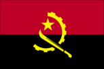
Flag description
two equal horizontal bands of red (top) and black with a centered yellow emblem consisting of a five-pointed star within half a cogwheel crossed by a machete (in the style of a hammer and sickle); red represents liberty and black the African continent; the symbols characterize workers and peasants
Government type
presidential republic
Independence
11 November 1975 (from Portugal)
International law organization participation
has not submitted an ICJ jurisdiction declaration; non-party state to the ICCt
International organization participation
ACP, AfDB, AU, CEMAC, CPLP, FAO, G-77, IAEA, IBRD, ICAO, ICRM, IDA, IFAD, IFC, IFRCS, ILO, IMF, IMO, Interpol, IOC, IOM, IPU, ISO (correspondent), ITSO, ITU, ITUC (NGOs), MIGA, NAM, OAS (observer), OPEC, SADC, UN, UNCTAD, UNESCO, UNIDO, Union Latina, UNWTO, UPU, WCO, WFTU (NGOs), WHO, WIPO, WMO, WTO
Judicial branch
- highest courts
- Supreme Court or Supremo Tribunal de Justica (consists of the court president, vice president, and a minimum of 16 judges); Constitutional Court or Tribunal Constitucional (consists of 11 judges)
- judge selection and term of office
- Supreme Court judges appointed by the president upon recommendation of the Supreme Judicial Council, an 18-member body chaired by the president; judge tenure NA; Constitutional Court judges - 4 nominated by the president, 4 elected by National Assembly, 2 elected by Supreme National Council, 1 elected by competitive submission of curricula; judges serve single 7-year terms
- subordinate courts
- provincial and municipal courts
Legal system
civil legal system based on Portuguese civil law; no judicial review of legislation
Legislative branch
- description
- unicameral National Assembly or Assembleia Nacional (220 seats; members directly elected in a single national constituency and in multi-seat constituencies by closed list proportional representation vote; members serve 5-year terms)
- election results
- percent of vote by party - MPLA 61.1%, UNITA 26.7%, CASA-CE 9.5%, PRS 1.4%, FNLA 0.9%, other 0.5%; seats by party - MPLA 150, UNITA 51, CASA-CE 16, PRS 2, FNLA 1; composition - men 136, women 84, percent of women 38.2%
- elections
- last held on 23 August 2017 (next to be held in August 2022)
National anthem
- lyrics/music
- Manuel Rui Alves MONTEIRO/Rui Alberto Vieira Dias MINGAO
- name
- "Angola Avante" (Forward Angola)
- note
- note: adopted 1975
National holiday
Independence Day, 11 November (1975)
National symbol(s)
Palanca Negra Gigante (giant black sable antelope); national colors: red, black, yellow
Political parties and leaders
Broad Convergence for the Salvation of Angola Electoral Coalition or CASA-CE [Andre Mendes de CARVALHO]National Front for the Liberation of Angola or FNLA; note - party has two factions; one led by Lucas NGONDA; the other by Ngola KABANGUNational Union for the Total Independence of Angola or UNITA [Isaias SAMAKUVA] (largest opposition party)Popular Movement for the Liberation of Angola or MPLA [Joao LOURENCO]; note - Jose Eduardo DOS SANTOS stepped down 8 Sept 2018 ruling party in power since 1975Social Renewal Party or PRS [Benedito DANIEL]
Suffrage
18 years of age; universal
Economy
Agricultural products
cassava, bananas, maize, sweet potatoes, pineapples, sugar cane, potatoes, citrus fruit, vegetables, cabbage
Budget
- expenditures
- 45.44 billion (2017 est.)
- revenues
- 37.02 billion (2017 est.)
Budget surplus (+) or deficit (-)
-6.7% (of GDP) (2017 est.)
Credit ratings
- Fitch rating
- CCC (2020)
- Moody's rating
- Caa1 (2020)
- Standard & Poors rating
- CCC+ (2020)
Current account balance
- Current account balance 2016
- -$4.834 billion (2016 est.)
- Current account balance 2017
- -$1.254 billion (2017 est.)
Debt - external
- Debt - external 31 December 2016
- $27.14 billion (31 December 2016 est.)
- Debt - external 31 December 2017
- $42.08 billion (31 December 2017 est.)
Economic overview
Angola's economy is overwhelmingly driven by its oil sector. Oil production and its supporting activities contribute about 50% of GDP, more than 70% of government revenue, and more than 90% of the country's exports; Angola is an OPEC member and subject to its direction regarding oil production levels. Diamonds contribute an additional 5% to exports. Subsistence agriculture provides the main livelihood for most of the people, but half of the country's food is still imported.Increased oil production supported growth averaging more than 17% per year from 2004 to 2008. A postwar reconstruction boom and resettlement of displaced persons led to high rates of growth in construction and agriculture as well. Some of the country's infrastructure is still damaged or undeveloped from the 27-year-long civil war (1975-2002). However, the government since 2005 has used billions of dollars in credit from China, Brazil, Portugal, Germany, Spain, and the EU to help rebuild Angola's public infrastructure. Land mines left from the war still mar the countryside, and as a result, the national military, international partners, and private Angolan firms all continue to remove them.The global recession that started in 2008 stalled Angola’s economic growth and many construction projects stopped because Luanda accrued billions in arrears to foreign construction companies when government revenue fell. Lower prices for oil and diamonds also resulted in GDP falling 0.7% in 2016. Angola formally abandoned its currency peg in 2009 but reinstituted it in April 2016 and maintains an overvalued exchange rate. In late 2016, Angola lost the last of its correspondent relationships with foreign banks, further exacerbating hard currency problems. Since 2013 the central bank has consistently spent down reserves to defend the kwanza, gradually allowing a 40% depreciation since late 2014. Consumer inflation declined from 325% in 2000 to less than 9% in 2014, before rising again to above 30% from 2015-2017.Continued low oil prices, the depreciation of the kwanza, and slower than expected growth in non-oil GDP have reduced growth prospects, although several major international oil companies remain in Angola. Corruption, especially in the extractive sectors, is a major long-term challenge that poses an additional threat to the economy.
Exchange rates
- currency
- kwanza (AOA) per US dollar -
- Exchange rates 2013
- 98.303 (2013 est.)
- Exchange rates 2014
- 120.061 (2014 est.)
- Exchange rates 2015
- 163.656 (2015 est.)
- Exchange rates 2016
- 163.656 (2016 est.)
- Exchange rates 2017
- 172.6 (2017 est.)
Exports
- Exports 2018
- $41.39 billion note: data are in current year dollars (2018 est.)
- Exports 2019
- $35.18 billion note: data are in current year dollars (2019 est.)
- Exports 2020
- $21 billion note: data are in current year dollars (2020 est.)
Exports - commodities
crude petroleum, diamonds, natural gas, refined petroleum, ships (2019)
Exports - partners
China 62%, India 10%, United Arab Emirates 4%, Portugal 3%, Spain 3% (2019)
Fiscal year
calendar year
GDP - composition, by end use
- exports of goods and services
- 25.4% (2017 est.)
- government consumption
- 15.6% (2017 est.)
- household consumption
- 80.6% (2017 est.)
- imports of goods and services
- -30.7% (2017 est.)
- investment in fixed capital
- 10.3% (2017 est.)
- investment in inventories
- -1.2% (2017 est.)
GDP - composition, by sector of origin
- agriculture
- 10.2% (2011 est.)
- industry
- 61.4% (2011 est.)
- services
- 28.4% (2011 est.)
GDP (official exchange rate)
$97.261 billion (2019 est.)
Gini Index coefficient - distribution of family income
- Gini Index coefficient - distribution of family income 2018
- 51.3 (2018 est.)
Household income or consumption by percentage share
- highest 10%
- 44.7% (2000)
- lowest 10%
- 0.6%
Imports
- Imports 2018
- $25.89 billion note: data are in current year dollars (2018 est.)
- Imports 2019
- $22.3 billion note: data are in current year dollars (2019 est.)
- Imports 2020
- $15.12 billion note: data are in current year dollars (2020 est.)
Imports - commodities
refined petroleum, scrap vessels, meat, rice, palm oil (2019)
Imports - partners
China 22%, Portugal 15%, Nigeria 6%, Belgium 6%, United States 5%, South Africa 5%, Brazil 5% (2019)
Industrial production growth rate
2.5% (2017 est.)
Industries
petroleum; diamonds, iron ore, phosphates, feldspar, bauxite, uranium, and gold; cement; basic metal products; fish processing; food processing, brewing, tobacco products, sugar; textiles; ship repair
Inflation rate (consumer prices)
- Inflation rate (consumer prices) 2017
- 32.1% (2017 est.)
- Inflation rate (consumer prices) 2018
- 20.3% (2018 est.)
- Inflation rate (consumer prices) 2019
- 17.2% (2019 est.)
Labor force
12.51 million (2017 est.)
Labor force - by occupation
- agriculture
- 85%
- industry
- 15% (2015 est.)
- industry and services
- 15% (2003 est.)
Population below poverty line
32.3% (2018 est.)
Public debt
- Public debt 2016
- 75.3% of GDP (2016 est.)
- Public debt 2017
- 65% of GDP (2017 est.)
Real GDP (purchasing power parity)
- note
- note: data are in 2010 dollars
- Real GDP (purchasing power parity) 2018
- $213.62 billion note: data are in 2017 dollars (2018 est.)
- Real GDP (purchasing power parity) 2019
- $212.29 billion note: data are in 2017 dollars (2019 est.)
- Real GDP (purchasing power parity) 2020
- $203.71 billion note: data are in 2017 dollars (2020 est.)
Real GDP growth rate
- Real GDP growth rate 2015
- 0.9% (2015 est.)
- Real GDP growth rate 2016
- -2.6% (2016 est.)
- Real GDP growth rate 2017
- -2.5% (2017 est.)
Real GDP per capita
- note
- note: data are in 2010 dollars
- Real GDP per capita 2018
- $6,900 note: data are in 2017 dollars (2018 est.)
- Real GDP per capita 2019
- $6,700 note: data are in 2017 dollars (2019 est.)
- Real GDP per capita 2020
- $6,200 note: data are in 2017 dollars (2020 est.)
Reserves of foreign exchange and gold
- Reserves of foreign exchange and gold 31 December 2016
- $23.74 billion (31 December 2016 est.)
- Reserves of foreign exchange and gold 31 December 2017
- $17.29 billion (31 December 2017 est.)
Taxes and other revenues
29.3% (of GDP) (2017 est.)
Unemployment rate
- Unemployment rate 2016
- 6.6% (2016 est.)
Unemployment, youth ages 15-24
- female
- 16.7% (2014 est.)
- male
- 17.9%
- total
- 17.3%
Energy
Crude oil - exports
1.782 million bbl/day (2015 est.)
Crude oil - imports
0 bbl/day (2015 est.)
Crude oil - production
1.593 million bbl/day (2018 est.)
Crude oil - proved reserves
9.523 billion bbl (1 January 2018 est.)
Electricity - consumption
9.036 billion kWh (2016 est.)
Electricity - exports
0 kWh (2016 est.)
Electricity - from fossil fuels
34% of total installed capacity (2016 est.)
Electricity - from hydroelectric plants
64% of total installed capacity (2017 est.)
Electricity - from nuclear fuels
0% of total installed capacity (2017 est.)
Electricity - from other renewable sources
2% of total installed capacity (2017 est.)
Electricity - imports
0 kWh (2016 est.)
Electricity - installed generating capacity
2.613 million kW (2016 est.)
Electricity - production
10.2 billion kWh (2016 est.)
Electricity access
- electrification - rural areas
- 6% (2019)
- electrification - total population
- 43% (2019)
- electrification - urban areas
- 61% (2019)
Natural gas - consumption
821.2 million cu m (2017 est.)
Natural gas - exports
3.993 billion cu m (2017 est.)
Natural gas - imports
0 cu m (2017 est.)
Natural gas - production
3.115 billion cu m (2017 est.)
Natural gas - proved reserves
308.1 billion cu m (1 January 2018 est.)
Refined petroleum products - consumption
130,000 bbl/day (2016 est.)
Refined petroleum products - exports
30,340 bbl/day (2015 est.)
Refined petroleum products - imports
111,600 bbl/day (2015 est.)
Refined petroleum products - production
53,480 bbl/day (2015 est.)
Communications
Broadband - fixed subscriptions
- subscriptions per 100 inhabitants
- less than 1 (2020 est.)
- total
- 230,610 (2020)
Broadcast media
state controls all broadcast media with nationwide reach; state-owned Televisao Popular de Angola (TPA) provides terrestrial TV service on 2 channels; a third TPA channel is available via cable and satellite; TV subscription services are available; state-owned Radio Nacional de Angola (RNA) broadcasts on 5 stations; about a half-dozen private radio stations broadcast locally
Internet country code
.ao
Internet users
- percent of population
- 36% (2019 est.)
- total
- 10.36 million (2021 est.)
Telecommunication systems
- domestic
- only about one fixed-line per 100 persons; mobile-cellular teledensity about 47 telephones per 100 persons (2019)
- general assessment
- Angola’s telecom sector shows consistent recovery following political stability, encouraging foreign investment; while the government opened the telecom sector to new competitors, there has been slow progress in LTE network development; only a small proportion of the country is covered by the 3G network infrastructure; Internet and mobile phone penetration remains low, hindered by high costs and poor infrastructure that limits access, especially in rural areas; upgrading telecom will support e-commerce, and rural access to education and health care; AngoSat-2 satellite expected to be ready in 2021; government aims to connect an additional 160,000 people to free Wi-Fi; importer of broadcasting equipment from China (2021)
- international
- country code - 244; landing points for the SAT-3/WASC, WACS, ACE and SACS fiber-optic submarine cable that provides connectivity to other countries in west Africa, Brazil, Europe and Asia; satellite earth stations - 29, Angosat-2 satellite expected by 2021 (2019)
- note
- note: the COVID-19 pandemic continues to have a significant impact on production and supply chains globally; since 2020, some aspects of the telecom sector have experienced downturn, particularly in mobile device production; many network operators delayed upgrades to infrastructure; progress towards 5G implementation was postponed or slowed in some countries; consumer spending on telecom services and devices was affected by large-scale job losses and the consequent restriction on disposable incomes; the crucial nature of telecom services as a tool for work and school from home became evident, and received some support from governments
Telephones - fixed lines
- subscriptions per 100 inhabitants
- less than 1 (2020)
- total subscriptions
- 119,164 (2020)
Telephones - mobile cellular
- subscriptions per 100 inhabitants
- 44.56 (2020 est.)
- total subscriptions
- 14,645,050 (2020)
Transportation
Airports
- total
- 102 (2020)
Airports - with paved runways
- 1,524 to 2,437 m
- 10
- 2,438 to 3,047 m
- 8
- 914 to 1,523 m
- 6 (2020)
- over 3,047 m
- 8
- total
- 32
Airports - with unpaved runways
- 1,524 to 2,437 m
- 17
- 2,438 to 3,047 m
- 2
- 914 to 1,523 m
- 27
- over 3,047 m
- 2
- total
- 70
- under 914 m
- 22 (2020)
Civil aircraft registration country code prefix
D2
Heliports
1 (2013)
Merchant marine
- by type
- general cargo 13, oil tanker 8, other 33 (2021)
- total
- 54
National air transport system
- annual freight traffic on registered air carriers
- 78.16 million mt-km (2018)
- annual passenger traffic on registered air carriers
- 1,516,628 (2018)
- inventory of registered aircraft operated by air carriers
- 55
- number of registered air carriers
- 10 (2020)
Pipelines
352 km gas, 85 km liquid petroleum gas, 1065 km oil, 5 km oil/gas/water (2013)
Ports and terminals
- LNG terminal(s) (export)
- Angola Soyo
- major seaport(s)
- Cabinda, Lobito, Luanda, Namibe
Railways
- narrow gauge
- 2,729 km 1.067-m gauge (2014)
- note
- 123 km 0.600-m gauge
- total
- 2,852 km (2014)
Roadways
- paved
- 13,600 km (2018)
- total
- 26,000 km (2018)
- unpaved
- 12,400 km (2018)
Waterways
1,300 km (2011)
Military and Security
Military - note
the Angolan Armed Forces were created in 1991 under the Bicesse Accords signed between the Angolan Government and the National Union for the Total Independence of Angola (UNITA); the name remained even after UNITA rejected the 1992 election results and returned to fighting against the Angolan Government the Angolan Armed Forces are responsible for external security but also have domestic security responsibilities, including border security, expulsion of irregular migrants, and small-scale actions against groups like the Front for the Liberation of the Enclave of Cabinda separatists in Cabinda
Military and security forces
Angolan Armed Forces (Forcas Armadas Angolanas, FAA): Army, Navy (Marinha de Guerra Angola, MGA), Angolan National Air Force (Forca Aerea Nacional Angolana, FANA; under operational control of the Army); Rapid Reaction Police (paramilitary) (2021)
Military and security service personnel strengths
the Angolan Armed Forces (FAA) are comprised of approximately 107,000 active troops (100,000 Army; 1,000 Navy; 6,000 Air Force); est. 10,000 Rapid Reaction Police (2021)
Military equipment inventories and acquisitions
most Angolan military weapons and equipment are of Russian, Soviet, or Warsaw Pact origin; since 2010, Russia has remained the principle supplier of military hardware to Angola (2020)
Military expenditures
- Military Expenditures 2016
- 3% of GDP (2016)
- Military Expenditures 2017
- 2.4% of GDP (2017)
- Military Expenditures 2018
- 1.8% of GDP (2018)
- Military Expenditures 2019
- 1.7% of GDP (2019)
- Military Expenditures 2020
- 1.7% of GDP (2020 est.)
Military service age and obligation
20-45 years of age for compulsory male and 18-45 years for voluntary male military service (registration at age 18 is mandatory); 20-45 years of age for voluntary female service; 2-year conscript service obligation; Angolan citizenship required; the Navy (MGA) is entirely staffed with volunteers (2019)
Transnational Issues
Disputes - international
Democratic Republic of Congo accuses Angola of shifting monuments
Illicit drugs
used as a transshipment point for cocaine destined for Western Europe and other African states, particularly South Africa
Refugees and internally displaced persons
- refugees (country of origin)
- 37,426 (Democratic Republic of the Congo) (refugees and asylum seekers), 9,272 (Guinea), 6,357 (Cote d'Ivoire), 5,725 (Mauritania) (2021)
Environment
Air pollutants
- carbon dioxide emissions
- 34.69 megatons (2016 est.)
- methane emissions
- 23.28 megatons (2020 est.)
- particulate matter emissions
- 27.95 micrograms per cubic meter (2016 est.)
Climate
semiarid in south and along coast to Luanda; north has cool, dry season (May to October) and hot, rainy season (November to April)
Environment - current issues
overuse of pastures and subsequent soil erosion attributable to population pressures; desertification; deforestation of tropical rain forest, in response to both international demand for tropical timber and to domestic use as fuel, resulting in loss of biodiversity; soil erosion contributing to water pollution and siltation of rivers and dams; inadequate supplies of potable water
Environment - international agreements
- party to
- Biodiversity, Climate Change, Climate Change-Kyoto Protocol, Climate Change-Paris Agreement, Comprehensive Nuclear Test Ban, Desertification, Endangered Species, Hazardous Wastes, Law of the Sea, Marine Dumping-London Protocol, Ozone Layer Protection, Ship Pollution
- signed, but not ratified
- none of the selected agreements
Land use
- agricultural land
- 45.7% (2018 est.)
- agricultural land: arable land
- arable land: 3.9% (2018 est.)
- agricultural land: permanent crops
- permanent crops: 0.3% (2018 est.)
- agricultural land: permanent pasture
- permanent pasture: 41.5% (2018 est.)
- forest
- 54.3% (2018 est.)
Major aquifers
Congo Basin, Upper Kalahari-Cuvelai-Upper Zambezi Basin
Major infectious diseases
- animal contact diseases
- rabies
- degree of risk
- very high (2020)
- food or waterborne diseases
- bacterial and protozoal diarrhea, hepatitis A, typhoid fever
- vectorborne diseases
- dengue fever, malaria
- water contact diseases
- schistosomiasis
Major rivers (by length in km)
Zambezi (shared with Zambia [s], Namibia, Botswana, Zimbabwe, and Mozambique [m]) - 2,740 km; Okavango river source (shared with Namibia and Botswana [m]) - 1,600 kmnote – [s] after country name indicates river source; [m] after country name indicates river mouth
Major watersheds (area sq km)
Atlantic Ocean drainage: Congo (3,730,881 sq km)Indian Ocean drainage: Zambezi (1,332,412 sq km)Internal (endorheic basin) drainage: Okavango Basin (863,866 sq km)
Revenue from coal
- coal revenues
- 0% of GDP (2018 est.)
Revenue from forest resources
- forest revenues
- 0.36% of GDP (2018 est.)
Total renewable water resources
148.4 billion cubic meters (2017 est.)
Total water withdrawal
- agricultural
- 146.7 million cubic meters (2017 est.)
- industrial
- 239.6 million cubic meters (2017 est.)
- municipal
- 319.5 million cubic meters (2017 est.)
Urbanization
- rate of urbanization
- 4.04% annual rate of change (2020-25 est.)
- urban population
- 67.5% of total population (2021)
Waste and recycling
- municipal solid waste generated annually
- 4,213,644 tons (2012 est.)