2001 Edition
CIA World Factbook 2001 (Project Gutenberg)
Introduction
Administrative divisions
30 provinces (velayat, singular - velayat); Badakhshan, Badghis, Baghlan, Balkh, Bamian, Farah, Faryab, Ghazni, Ghowr, Helmand, Herat, Jowzjan, Kabol, Kandahar, Kapisa, Konar, Kondoz, Laghman, Lowgar, Nangarhar, Nimruz, Oruzgan, Paktia, Paktika, Parvan, Samangan, Sar-e Pol, Takhar, Vardak, Zabol; note - there may be two new provinces of Nurestan (Nuristan) and Khowst
Age structure
0-14 years: 42.2% (male 5,775,921; female 5,538,836) 15-64 years: 55.01% (male 7,644,242; female 7,106,568) 65 years and over: 2.79% (male 394,444; female 353,046) (2001 est.)
Agriculture - products
opium poppies, wheat, fruits, nuts; wool, mutton, karakul pelts
Airports
45 (2000 est.)
Airports - with paved runways
total: 10 over 3,047 m: 3 2,438 to 3,047 m: 4 1,524 to 2,437 m: 2 under 914 m: 1 (2000 est.)
Airports - with unpaved runways
total: 35 2,438 to 3,047 m: 4 1,524 to 2,437 m: 15 914 to 1,523 m: 4 under 914 m: 12 (2000 est.)
Area
total: 647,500 sq km land: 647,500 sq km water: 0 sq km
Area - comparative
slightly smaller than Texas
Background
Afghanistan was invaded and occupied by the Soviet Union in 1979. The USSR was forced to withdraw 10 years later by anti-communist mujahidin forces supplied and trained by the US, Saudi Arabia, Pakistan, and others. Fighting subsequently continued among the various mujahidin factions, but the fundamentalist Islamic Taliban movement has been able to seize most of the country. In addition to the continuing civil strife, the country suffers from enormous poverty, a crumbling infrastructure, and widespread land mines. Afghanistan Geography
Birth rate
41.42 births/1,000 population (2001 est.)
Budget
revenues: $NA expenditures: $NA, including capital expenditures of $NA
Capital
Kabul
Climate
arid to semiarid; cold winters and hot summers
Coastline
0 km (landlocked)
Constitution
none
Country name
conventional long form: Islamic State of Afghanistan; note - the self-proclaimed Taliban government refers to the country as Islamic Emirate of Afghanistan conventional short form: Afghanistan local long form: Dowlat-e Eslami-ye Afghanestan local short form: Afghanestan former: Republic of Afghanistan
Currency
afghani (AFA)
Currency code
AFA
Death rate
17.72 deaths/1,000 population (2001 est.)
Debt - external
$5.5 billion (1996 est.)
Diplomatic representation from the US
the US embassy in Kabul has been closed since January 1989 due to security concerns
Diplomatic representation in the US
none; note - embassy operations suspended 21 August 1997 consulate(s) general: New York
Disputes - international
support to Islamic militants worldwide by some factions; question over which group should hold Afghanistan's seat at the UN
Economic aid - recipient
US provided about $70 million in humanitarian assistance in 1997; US continues to contribute to multilateral assistance through the UN programs of food aid, immunization, land mine removal, and a wide range of aid to refugees and displaced persons
Economy - overview
Afghanistan is an extremely poor, landlocked country, highly dependent on farming and livestock raising (sheep and goats). Economic considerations have played second fiddle to political and military upheavals during two decades of war, including the nearly 10-year Soviet military occupation (which ended 15 February 1989). During that conflict one-third of the population fled the country, with Pakistan and Iran sheltering a combined peak of more than 6 million refugees. In early 2000, 2 million Afghan refugees remained in Pakistan and about 1.4 million in Iran. Gross domestic product has fallen substantially over the past 20 years because of the loss of labor and capital and the disruption of trade and transport; severe drought added to the nation's difficulties in 1998-2000. The majority of the population continues to suffer from insufficient food, clothing, housing, and medical care. Inflation remains a serious problem throughout the country. International aid can deal with only a fraction of the humanitarian problem, let alone promote economic development. In 1999-2000, internal civil strife continued, hampering both domestic economic policies and international aid efforts. Numerical data are likely to be either unavailable or unreliable. Afghanistan was by far the largest producer of opium poppies in 2000, and narcotics trafficking is a major source of revenue.
Electricity - consumption
480.6 million kWh (1999)
Electricity - exports
0 kWh (1999)
Electricity - imports
90 million kWh (1999)
Electricity - production
420 million kWh (1999)
Electricity - production by source
fossil fuel: 35.71% hydro: 64.29% nuclear: 0% other: 0% (1999)
Elevation extremes
lowest point: Amu Darya 258 m highest point: Nowshak 7,485 m
Environment - current issues
soil degradation; overgrazing; deforestation (much of the remaining forests are being cut down for fuel and building materials); desertification
Environment - international agreements
party to: Desertification, Endangered Species, Environmental Modification, Marine Dumping, Nuclear Test Ban signed, but not ratified: Biodiversity, Climate Change, Hazardous Wastes, Law of the Sea, Marine Life Conservation
Ethnic groups
Pashtun 38%, Tajik 25%, Hazara 19%, minor ethnic groups (Aimaks, Turkmen, Baloch, and others) 12%, Uzbek 6%
Exchange rates
afghanis per US dollar - 4,700 (January 2000), 4,750 (February 1999), 17,000 (December 1996), 7,000 (January 1995), 1,900 (January 1994), 1,019 (March 1993), 850 (1991); note - these rates reflect the free market exchange rates rather than the official exchange rate, which was fixed at 50.600 afghanis to the dollar until 1996, when it rose to 2,262.65 per dollar, and finally became fixed again at 3,000.00 per dollar in April 1996
Executive branch
on 27 September 1996, the ruling members of the Afghan Government were displaced by members of the Islamic Taliban movement; the Islamic State of Afghanistan has no functioning government at this time, and the country remains divided among fighting factions note: the Taliban have declared themselves the legitimate government of Afghanistan; however, the UN still recognizes the government of Burhanuddin RABBANI; the Organization of the Islamic Conference has left the Afghan seat vacant until the question of legitimacy can be resolved through negotiations among the warring factions; the country is essentially divided along ethnic lines; the Taliban controls the capital of Kabul and approximately two-thirds of the country including the predominately ethnic Pashtun areas in southern Afghanistan; opposing factions have their stronghold in the ethnically diverse north
Exports
$80 million (does not include opium) (1996 est.)
Exports - commodities
opium, fruits and nuts, handwoven carpets, wool, cotton, hides and pelts, precious and semi-precious gems
Exports - partners
FSU, Pakistan, Iran, Germany, India, UK, Belgium, Luxembourg, Czech Republic
Fiscal year
21 March - 20 March Afghanistan Communications
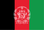
Flag description
three equal horizontal bands of green (top), white, and black with a gold emblem centered on the three bands; the emblem features a temple-like structure with Islamic inscriptions above and below, encircled by a wreath on the left and right and by a bolder Islamic inscription above, all of which are encircled by two crossed scimitars note: the Taliban uses a plain white flag Afghanistan Economy
GDP
purchasing power parity - $21 billion (2000 est.)
GDP - composition by sector
agriculture: 53% industry: 28.5% services: 18.5% (1990)
GDP - per capita
purchasing power parity - $800 (2000 est.)
GDP - real growth rate
NA%
Geographic coordinates
33 00 N, 65 00 E
Geography - note
landlocked Afghanistan People
Government type
no functioning central government, administered by factions
Heliports
3 (2000 est.) Afghanistan Military
Highways
total: 21,000 km paved: 2,793 km unpaved: 18,207 km (1998 est.)
HIV/AIDS - adult prevalence rate
less than 0.01% (1999 est.)
HIV/AIDS - deaths
NA
HIV/AIDS - people living with HIV/AIDS
NA
Household income or consumption by percentage share
lowest 10%: NA% highest 10%: NA%
Illicit drugs
world's largest illicit opium producer, surpassing Burma (potential production in 1999 - 1,670 metric tons; cultivation in 1999 - 51,500 hectares, a 23% increase over 1998); a major source of hashish; increasing number of heroin-processing laboratories being set up in the country; major political factions in the country profit from drug trade
Imports
$150 million (1996 est.)
Imports - commodities
capital goods, food and petroleum products; most consumer goods
Imports - partners
FSU, Pakistan, Iran, Japan, Singapore, India, South Korea, Germany
Independence
19 August 1919 (from UK control over Afghan foreign affairs)
Industries
small-scale production of textiles, soap, furniture, shoes, fertilizer, and cement; handwoven carpets; natural gas, oil, coal, copper
Infant mortality rate
147.02 deaths/1,000 live births (2001 est.)
Inflation rate (consumer prices)
NA%
International organization participation
AsDB, CP, ECO, ESCAP, FAO, G-77, IAEA, IBRD, ICAO, ICRM, IDA, IDB, IFAD, IFC, IFRCS, ILO, IMF, Intelsat, IOC, IOM (observer), ITU, NAM, OIC, OPCW, UN, UNCTAD, UNESCO, UNIDO, UPU, WFTU, WHO, WMO, WToO
Internet country code
.af
Internet Service Providers (ISPs)
1 (2000)
Internet users
NA Afghanistan Transportation
Irrigated land
30,000 sq km (1993 est.)
Judicial branch
upper courts were non-functioning as of March 1995 (local Shari'a or Islamic law courts are functioning throughout the country)
Labor force
10 million (2000 est.)
Labor force - by occupation
agriculture 70%, industry 15%, services 15% (1990 est.)
Land boundaries
total: 5,529 km border countries: China 76 km, Iran 936 km, Pakistan 2,430 km, Tajikistan 1,206 km, Turkmenistan 744 km, Uzbekistan 137 km
Land use
arable land: 12% permanent crops: 0% permanent pastures: 46% forests and woodland: 3% other: 39% (1993 est.)
Languages
Pashtu 35%, Afghan Persian (Dari) 50%, Turkic languages (primarily Uzbek and Turkmen) 11%, 30 minor languages (primarily Balochi and Pashai) 4%, much bilingualism
Legal system
a new legal system has not been adopted but all factions tacitly agree they will follow Shari'a (Islamic law)
Legislative branch
non-functioning as of June 1993
Life expectancy at birth
total population: 46.24 years male: 46.97 years female: 45.47 years (2001 est.)
Literacy
definition: age 15 and over can read and write total population: 31.5% male: 47.2% female: 15% (1999 est.) Afghanistan Government
Location
Southern Asia, north and west of Pakistan, east of Iran
Map references
Asia
Maritime claims
none (landlocked)
Military branches
NA; note - the military does not exist on a national basis; some elements of the former Army, Air and Air Defense Forces, National Guard, Border Guard Forces, National Police Force (Sarandoi), and tribal militias still exist but are factionalized among the various groups
Military expenditures - dollar figure
$NA
Military expenditures - percent of GDP
NA% Afghanistan Transnational Issues
Military manpower - availability
males age 15-49: 6,645,023 (2001 est.)
Military manpower - fit for military service
males age 15-49: 3,561,957 (2001 est.)
Military manpower - military age
22 years of age
Military manpower - reaching military age annually
males: 252,869 (2001 est.)
National holiday
Independence Day, 19 August (1919)
Nationality
noun: Afghan(s) adjective: Afghan
Natural hazards
damaging earthquakes occur in Hindu Kush mountains; flooding; droughts
Natural resources
natural gas, petroleum, coal, copper, chromite, talc, barites, sulfur, lead, zinc, iron ore, salt, precious and semiprecious stones
Net migration rate
11.11 migrant(s)/1,000 population (2001 est.)
Pipelines
petroleum products - Uzbekistan to Bagram and Turkmenistan to Shindand; natural gas 180 km
Political parties and leaders
Taliban (Religious Students Movement) [Mullah Mohammad OMAR]; United National Islamic Front for the Salvation of Afghanistan or UNIFSA [Burhanuddin RABBANI, chairman; Gen. Abdul Rashid DOSTAM, vice chairman; Ahmad Shah MASOOD, military commander; Mohammed Yunis QANUNI, spokesman]; note - made up of 13 parties opposed to the Taliban including Harakat-i-Islami Afghanistan (Islamic Movement of Afghanistan), Hizb-i-Islami (Islamic Party), Hizb-i-Wahdat-i-Islami (Islamic Unity Party), Jumaat-i-Islami Afghanistan (Islamic Afghan Society), Jumbish-i-Milli (National Front), Mahaz-i-Milli-i-Islami (National Islamic Front)
Political pressure groups and leaders
Afghan refugees in Pakistan, Australia, US, and elsewhere have organized politically; Mellat (Social Democratic Party) [leader NA]; Peshawar, Pakistan-based groups such as the Coordination Council for National Unity and Understanding in Afghanistan or CUNUA [Ishaq GAILANI]; tribal elders represent traditional Pashtun leadership; Writers Union of Free Afghanistan or WUFA [A. Rasul AMIN]
Population
26,813,057 (July 2001 est.)
Population below poverty line
NA%
Population growth rate
3.48% (2001 est.) note: this rate reflects the continued return of refugees from Iran
Ports and harbors
Kheyrabad, Shir Khan
Radio broadcast stations
AM 7 (6 are inactive; the active station is in Kabul), FM 1, shortwave 1 (broadcasts in Pushtu, Dari, Urdu, and English) (1999)
Radios
167,000 (1999)
Railways
total: 24.6 km broad gauge: 9.6 km 1.524-m gauge from Gushgy (Turkmenistan) to Towraghondi; 15 km 1.524-m gauge from Termiz (Uzbekistan) to Kheyrabad transshipment point on south bank of Amu Darya
Religions
Sunni Muslim 84%, Shi'a Muslim 15%, other 1%
Sex ratio
at birth: 1.05 male(s)/female under 15 years: 1.04 male(s)/female 15-64 years: 1.08 male(s)/female 65 years and over: 1.12 male(s)/female total population: 1.06 male(s)/female (2001 est.)
Suffrage
NA; previously males 15-50 years of age
Telephone system
general assessment: very limited telephone and telegraph service domestic: in 1997, telecommunications links were established between Mazar-e Sharif, Herat, Kandahar, Jalalabad, and Kabul through satellite and microwave systems international: satellite earth stations - 1 Intelsat (Indian Ocean) linked only to Iran and 1 Intersputnik (Atlantic Ocean region); commercial satellite telephone center in Ghazni
Telephones - main lines in use
29,000 (1996) note: there were 21,000 main lines in service in Kabul in 1998
Telephones - mobile cellular
NA
Television broadcast stations
at least 10 (one government run central television station in Kabul and regional stations in nine of the 30 provinces; the regional stations operate on a reduced schedule; also, in 1997, there was a station in Mazar-e Sharif reaching four northern Afghanistan provinces) (1998)
Televisions
100,000 (1999)
Terrain
mostly rugged mountains; plains in north and southwest
Total fertility rate
5.79 children born/woman (2001 est.)
Unemployment rate
NA%
Waterways
1,200 km note: chiefly Amu Darya, which handles vessels with DWT up to about 500 (2001)